The Maine 25: An Iconic Hiking Bucket List

From rugged coastlines and alpine ridgelines to fern-filled forests and remote ponds, Maine offers unforgettable hiking experiences across its vast and varied landscapes. Whether you’re a seasoned summit-seeker or a casual wanderer, this bucket list of Maine’s 25 most iconic hikes celebrates the broad natural landscapes the Pine Tree State has to offer. Each hike description below includes one nature-rich highlight, a tip to make the most of your visit, and essential stats for planning.
Use our map to start trip planning now!
1. Tumbledown Mountain

What makes it special: A pristine alpine pond sparkles just below the rocky summit, surrounded by blueberry bushes and wildflowers.
Tip: Take the Loop Trail up and Brook Trail down for a challenging loop with a refreshing swim.
Trail Stats: Distance: 5.6 miles (loop) | Difficulty: Challenging | Elevation Gain: 1,900 ft
Map and Guide: AllTrails Route | Maine Natural Heritage Hikes - Tumbledown Brochure
Trailkeeper: Maine Bureau of Parks and Lands
2. Mount Katahdin

What makes it special: Traverse the Knife Edge and witness rare alpine flora like diapensia dotting the ridgeline.
Tip: Start (very) early and be prepared for rapidly changing weather above the treeline. Book parking in advance.
Trail Stats: Distance: 9.1 miles (out & back) | Difficulty: Very challenging | Elevation Gain: 4,100 ft
Map and Guide: AllTrails Route | Maine Trail Finder: Katahdin
Trailkeeper: Baxter State Park
3. Cadillac Mountain

What makes it special: The first rays of sunrise in the U.S. light up the ocean and surrounding islands.
Tip: Hike up South Ridge Trail at dawn to earn your summit sunrise.
HIking Stats: Distance: 7 miles (out & back) | Difficulty: Moderate | Elevation Gain: 1,350 ft
Map and Guide: AllTrails Route | Acadia National Park Trail Summary
Trailkeeper: Acadia National Park
4. Gulf Hagas
What makes it special: A slate-walled gorge hides roaring waterfalls and ancient mossy groves.
Tip: Bring sturdy footwear—you’ll cross the West Branch of the Pleasant River on foot.
Hiking Stats: Distance: 8.6 miles (loop) | Difficulty: Moderate | Elevation Gain: 950 ft
Map and Guide: AllTrails Route | Gulf Hagas - Maine Trail Finder
Trailkeeper: Maine Appalachian Trail Club
5. The Beehive

What makes it special: Iron rungs and exposed cliffs lead to panoramic views of Sand Beach and the Gulf of Maine.
Tip: Only hike up the Beehive if you’re comfortable with heights—descend via the Bowl Trail.
Hiking Stats: Distance: 1.5 miles (loop) | Difficulty: Moderate to difficult | Elevation Gain: 500 ft
Map and Guide: All Trails Route | Acadia National Park - Beehive Loop - Maine Trail Finder
Trailkeeper: Acadia National Park
6. Bigelow Mountain — Avery Peak
What makes it special: It is one of Maine’s highest peaks with sweeping views of Flagstaff Lake and Canada jay flyovers!
Tip: Backpack the entire Bigelow Range Trail for a multi-day adventure.
Hiking Stats: Distance: 9 miles (out & back) | Difficulty: Difficult | Elevation Gain: 3,000 ft
Map and Guide: All Trails Route | Appalachian Trail - Bigelow Preserve - Maine Trail Finder
Trailkeeper: Bigelow Public Reserved Land - Maine Department of Agriculture and Forestry
7. Mount Battie
What makes it special: Wild lupines and warblers line the trail in early summer as you ascend to an ocean overlook.
Tip: Bring a picnic to enjoy the harbor view from the stone tower.
Hiking Stats: Distance: 1.5 miles (out & back) | Difficulty: Easy to moderate | Elevation Gain: 600 ft
Map and Guide: All Trails Route | Camden Hills State Park - Southern Trail Network - Maine Trail Finder
Trailkeeper: Camden Hills State Park
8. Cutler Bold Coast
What makes it special: Peat bogs and sea cliffs form a dramatic coastal wilderness teeming with seabirds.
Tip: Camp overnight to catch a whale jumping over the sunrise on the open ocean (well…this is your best shot 😂 🐋).
Hiking Stats: Distance: 9.4 miles (out & back) | Difficulty: Moderate | Elevation Gain: 1,154 ft
Map and Guide: All Trails Route | Cutler Coast Public Reserved Land - Maine Trail Finder
Trailkeeper: Cutler Coast Public Reserved Land
9. Borestone Mountain
What makes it special: A wildlife sanctuary trail with interpretive signs, dragonflies, and summit views of Lake Onawa.
Tip: Visit in June to see pink lady’s slippers blooming along the path.
Hiking Stats: Distance: 3.7 miles (loop) | Difficulty: Moderate | Elevation Gain: 1,200 ft
Map and Guide: All Trails Route | Borestone Mountain Audubon Sanctuary - Maine Trail Finder
Trailkeeper: Borestone Mountain Audubon Sanctuary
10. Pleasant Mountain

What makes it special: Boulders and birch groves decorate the trail to southern Maine’s tallest summit.
Tip: Use the Ledges Trail for the best mix of views and challenge.
Hiking Stats: Distance: 3.5 miles (out & back) | Difficulty: Hard | Elevation Gain: 1,500 ft
Map and Guide: All Trails Route | Pleasant Mountain Trails - Maine Trail Finder
Trailkeeper: Loon Echo Land Trust
11. Moxie Falls
What makes it special: One of Maine’s tallest waterfalls plunges 90 feet into a mossy gorge.
Tip: Bring the bug spray and your fishing rod for brook trout nearby.
Hiking Stats: Distance: 2 miles (out & back) | Difficulty: Easy | Elevation Gain: 300 ft
More info: All Trails Route | Moxie Falls - Maine Trail Finder
Trailkeeper: Moxie Gore Public Reserved Land
12. Bradbury Mountain

What makes it special: A small summit with big views over rolling farmland and hawk migration routes.
Tip: Visit in spring for the annual Hawk Watch.
Hiking Stats: Distance: 1.4 miles (loop) | Difficulty: Easy | Elevation Gain: 485 ft
Map and Guide: All Trails Route | Bradbury Mountain State Park - Hiking Trails - Maine Trail Finder
Trailkeeper: Bradbury Mountain State Park
13. Table Rock
What makes it special: A sheer cliff perch with dramatic views of the Eyebrow and surrounding mountains.
Tip: Take the steep Orange Trail up, Blue Trail down for variety.
Hiking Stats: Distance: 2.1 miles (loop) | Difficulty: Hard | Elevation Gain: 900 ft
Map and Guide: All Trails Route | Grafton Notch State Park - Maine Trail Finder
Trailkeeper: Grafton Notch State Park
14. Little Moose Mountain

What makes it special: A hidden gem with clifftop views of Moosehead Lake and dense fern glades.
Tip: Catch morning fog rising over the lake from the east-facing overlook.
Hiking Stats: Distance: 4.3 miles (loop) | Difficulty: Moderate | Elevation Gain: 650 ft
Map and Guide: All Trails Route | Little Moose Mountain - Maine Trail Finder
Trailkeeper: Little Moose Public Reserved Land
15. Mount Kineo
What makes it special: A fire tower caps a dramatic cliff rising from an island in Maine’s largest lake.
Tip: Catch the seasonal shuttle boat from Rockwood to start the hike.
Hiking Stats: Distance: 3.3 miles (loop) | Difficulty: Moderate | Elevation Gain: 900 ft
Map and Guide: All Trails Route | Mount Kineo State Park - Maine Trail Finder
Trailkeeper: Mount Kineo State Park
16. Dorr Mountain
What makes it special: You can see Cadillac Mountain, The Tarn, and Champlain Mountain from the summit.
Tip: Take the North Ridge Trail to Gorge Path Loop for a dog-friendly route (must be on a leash).
Hiking Stats: Distance: 3.2 miles (loop) | Difficulty: Hard | Elevation Gain: 1,184 ft
Map and Guide: All Trails Route | Dorr Mountain South Ridge Loop - Maine Trail Finder
Trailkeeper: Acadia National Park
17. Goose Eye Mountain
What makes it special: Part of the Appalachian Trail, Goose Eye’s alpine ridgeline bursts with blueberries in July.
Tip: Hike into the Mahoosucs in late summer for ripe berries and fewer bugs.
Hiking Stats: Distance: 8.7 miles (out & back) | Difficulty: Hard | Elevation Gain: 2,762 ft
Map and Guide: All Trails Route | Carlo Col and Goose Eye Trails - Maine Trail Finder
Trailkeeper: Maine Bureau of Parks and Lands
18. Mount Megunticook & Maiden Cliff
What makes it special: Combines lake and ocean views with a cliffside cross commemorating a local legend.
Tip: Begin at Maiden Cliff and loop back via Ridge Trail for best scenery.
Hiking Stats: Distance: 5.1 miles (out & back) | Difficulty: Hard | Elevation Gain: 1,456 ft
Map and Guide: All Trails Route | Camden Hills State Park - Maine Trail Finder
Trailkeeper: Camden Hills State Park
19. Bald Mountain
What makes it special: Wide ledges offer pristine views of the Rangeley Lakes and brilliant foliage in fall.
Tip: Sunset hikes here are unforgettable—bring a headlamp for the descent. And don’t confuse this Bald Mountain in Oquossuc with one of the several other Bald Mountains across Maine!
Hiking Stats: Distance: 2.3 miles (out & back) | Difficulty: Moderate | Elevation Gain: 734 ft
Map and Guide: All Trails Route | Bald Mountain - Maine Trail Finder
Trailkeeper: Bald Mountain-Little Concord Pond Parcel
20. Mount Blue
What makes it special: A fire tower marks the summit above old-growth trees and bear tracks.
Tip: After your hike, cool off in Webb Lake beach below.
Hiking Stats: Distance: 2.8 miles (out & back) | Difficulty: Hard | Elevation Gain: 1,781 ft
Map and Guide: All Trails Route | Mount Blue Trail - Maine Trail Finder
Trailkeeper: Mount Blue State Park
21. Angel Falls
What makes it special: This hike leads to a beautiful waterfall, one of the most impressive in Maine!
Tip: The streams may be impossible to walk through in high water so plan your trip on a week it won’t rain.
Hiking Stats: Distance: 1 mile (out & back) | Difficulty: Moderate | Elevation Gain: 249 ft
Map and Guide: All Trails Route | Angel Falls - Maine Trail Finder
Trailkeeper: Trails for Rangeley Area Coalition
22. Old Speck
What makes it special: There is a fire tower at the top of this trail and Grafton Notch State Park is also part of the Maine Birding Trail.
Tip: Start at the Appalachian Trail trailhead from Route 26/Bear River Road and follow the AT south.
Hiking Stats: Distance: 7.1 mile (out & back) | Difficulty: Difficult | Elevation Gain: 2,765 ft
Map and Guide: All Trails Route | Grafton Notch State Park - Old Speck Mountain and Eyebrow Loop - Maine Trail Finder
Trailkeeper: Trails for Rangeley Area Coalition
23. Blueberry Mountain

What makes it special: You can typically see peaks of Tumbledown, Bald, and Mt. Blue, and more distant peaks like Saddleback, Mt. Abram, Sugarloaf. On super clear days, you can even see the Bigelow Mountains Range and Mt. Washington.
Tip: Be ready to pick blueberries and eat them on the way up the White Cairn Trail to Stone House Trail! *Bonus Tip: You can take a dip in Rattlesnake Pool on the way down, so bring your swimsuit!
Hiking Stats: Distance: 4 miles (loop) | Difficulty: Moderate | Elevation Gain: 1,187 ft
Map and Guide: All Trails Route | Blueberry Mountain Trail - Maine Trail Finder
Trailkeeper: White Mountain National Forest
24. Mount Agamenticus
What makes it special: The peak was the location of the United States’ first radar tower!
Tip: There are 17 trails that go up and around the mountain, so come prepared to try a few. Learn more about events and programs at Agamenticus.org.
Hiking Stats: Distance: 1.6 mile (loop) | Difficulty: Moderate | Elevation Gain: 318 ft
Map and Guide: AllTrails Route | Mount Agamenticus - Maine Trail Finder
Trailkeeper: Mount Agamenticus Conservation Region
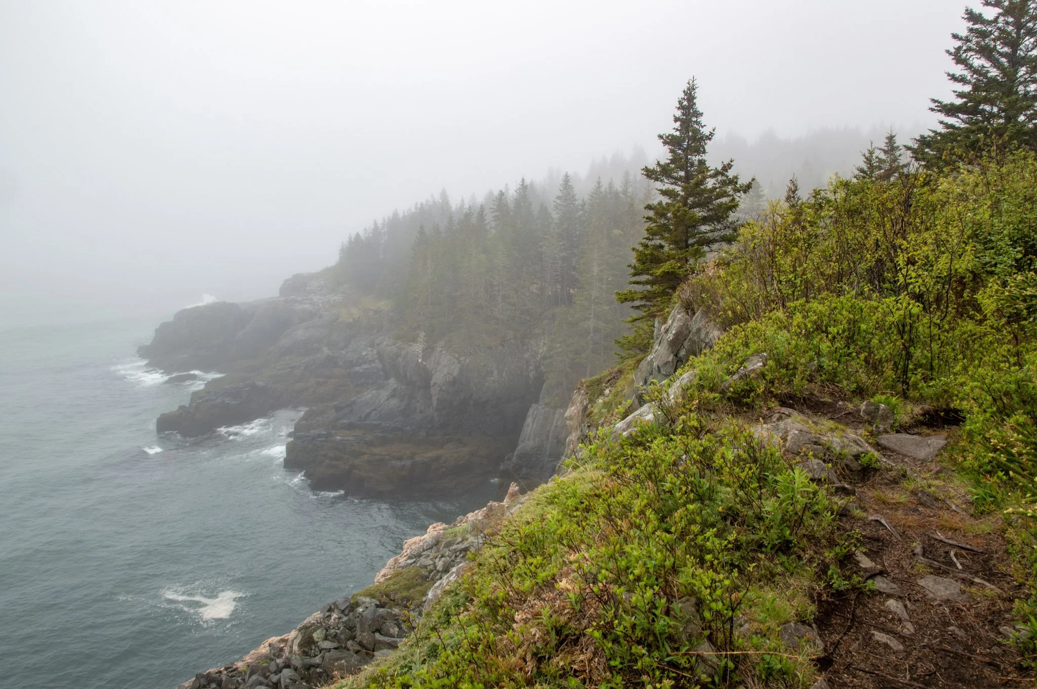
25. quoddy head
What makes it special: “Quoddy” means fertile and beautiful place - which couldn’t be truer.
Tip: Carrying Place Cove has a beach you can rest at on your way back so pack accordingly!
Hiking Stats: Distance: 3.6 mile (out & back) | Difficulty: Moderate | Elevation Gain: 298 ft
Map and Guide: AllTrails Route | Quoddy Head State Park - Maine Trail Finder
Trailkeeper: Quoddy Head State Park