A Bucket List Backpacking Trip on The Appalachian Trail
A First-Timer’s Guide to a Weekend in Maine’s Bigelows
If the thought of an endless stair climber in the heat of summer with the weight of a kindergartener on your back appeals to you, congratulations! We have the same brain. Might I recommend a hike?
📝 The Plan 📝
I was positively itching for a proper backpacking adventure over the Fourth of July this year; the variety-pack of blisters from my last hike had finally healed over and the holiday landing on a Friday seemed like divine providence, or at the very least some decent luck. I considered routes as far south as the Presidential Traverse and as far north as the Cutler Coast, but ultimately wanted to make it back to Portland in time for some belated Independence Day festivities. When scouring the internet for ideas, I remembered that years ago, a roommate had disappeared for several days into the Bigelow Preserve in western Maine and returned exhausted, battle-worn, and displaying her gorgeous photos like badges of honor. It seemed like the perfect opportunity to finally give the gigantic, iconic public preserve a fair shake.
Luckily for me, there are seemingly endless hiking options in the Bigelow Preserve. Created by public referendum in 1976, it now encompasses more than 36,000 acres of public land. It is bordered to the north by the beautiful Flagstaff Lake and includes about 17 miles of the Appalachian Trail and all seven summits in the Bigelow Range. These peaks are nothing to sneer at - in fact, Bigelow Mountain's West and Avery subpeaks are two of only ten Maine summits with more than 4,000 feet of elevation. The best part is that due to its massive size and wealth of access points, the peaceful, uncrowded Bigelow Preserve remains something of a backpacker’s paradise. Even on a holiday weekend, I passed fewer than ten fellow hikers over the course of two days, and the only other car at the trailhead turned out to belong to a burly Maine Appalachian Trail Club caretaker. As an added bonus for my fellow dirtbags, the preserve is completely free and most campsites operate on a first-come, first-served basis.
Because I was after a one-night loop that I could complete with just one vehicle, I decided to enter the preserve on a dirt road access point off of Route 27 and connect the Esker Trail, Fire Wardens Trail, Appalachian Trail, and Horns Pond Trail into a relatively short, predictably grueling, and unfailingly breathtaking loop. All in all, my total mileage clocked in at just under 14, and my elevation gain fell just south of 4,000 feet. If you’re itching for a challenge, I would highly recommend this route; make sure to bag all four peaks along the way. If you’d like, you could also park directly along Route 27 and hike in on the AT for a similar experience and an ultimately fuller circle. If you’ve got even more time, you could easily spread out the trek by camping at the Cranberry Stream or Moose Falls campsites and transform the one-night grind into a luxurious two-night stay.
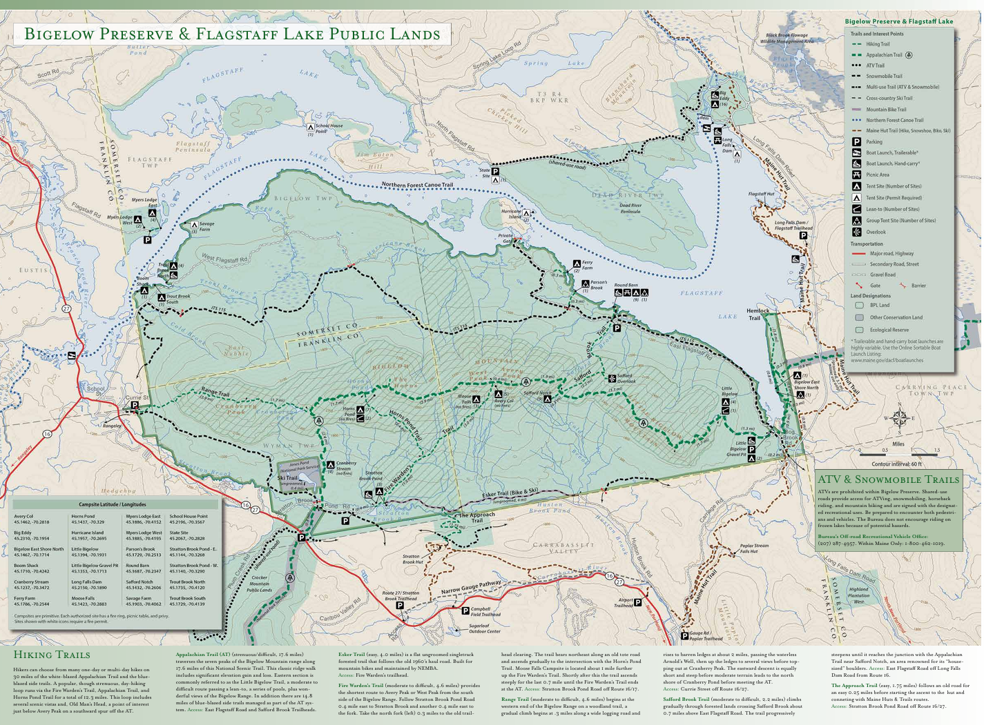
Here’s the full Bigelow Preserve. Shoutout to the Maine DACF for making the BEST maps. For a PDF version and better zooming controls, find it on maine.gov here!
🌄 On the Trail 🌄

The first mile follows the beautiful Stratton Brook Pond.
The trail begins tamely along Stratton Brook Pond but quickly picks up steepness as you head north towards the impressive range of peaks in the background. We - for I had brainwashed my loyal life/hiking partner into joining by promising him celebratory fried chicken - had planned to travel counterclockwise along the route, camping at the high-elevation Bigelow Col Campsite between the Avery and West Peaks. However, some serious lightning threatened on the horizon, and we ended up following the route clockwise instead so that we could take shelter at the Horns Pond Lean-tos during the storm.
As it turned out, that was a prophetic moment of decision-making. Even though our mileage that first day was miniscule, we were able to take cover in an Appalachian Trail shelter for the evening as torrential rain screamed down and the temperature dropped by nearly 20 degrees. We felt like we had scored into backpacking luxury; the lean-tos are well-maintained by the Maine Appalachian Trail Club and there are two privies, a knowledgeable caretaker, and a beautiful lake to filter water out of if needed. We also ran into several very wet AT thru-hikers squelching north towards Katahdin to finish their odyssey!

Me in front of Horns Pond before starting day two of the hike

Jake drinking through a LifeStraw from Horns Pond

The elevator-shaft-like climbs - not a switchback in sight
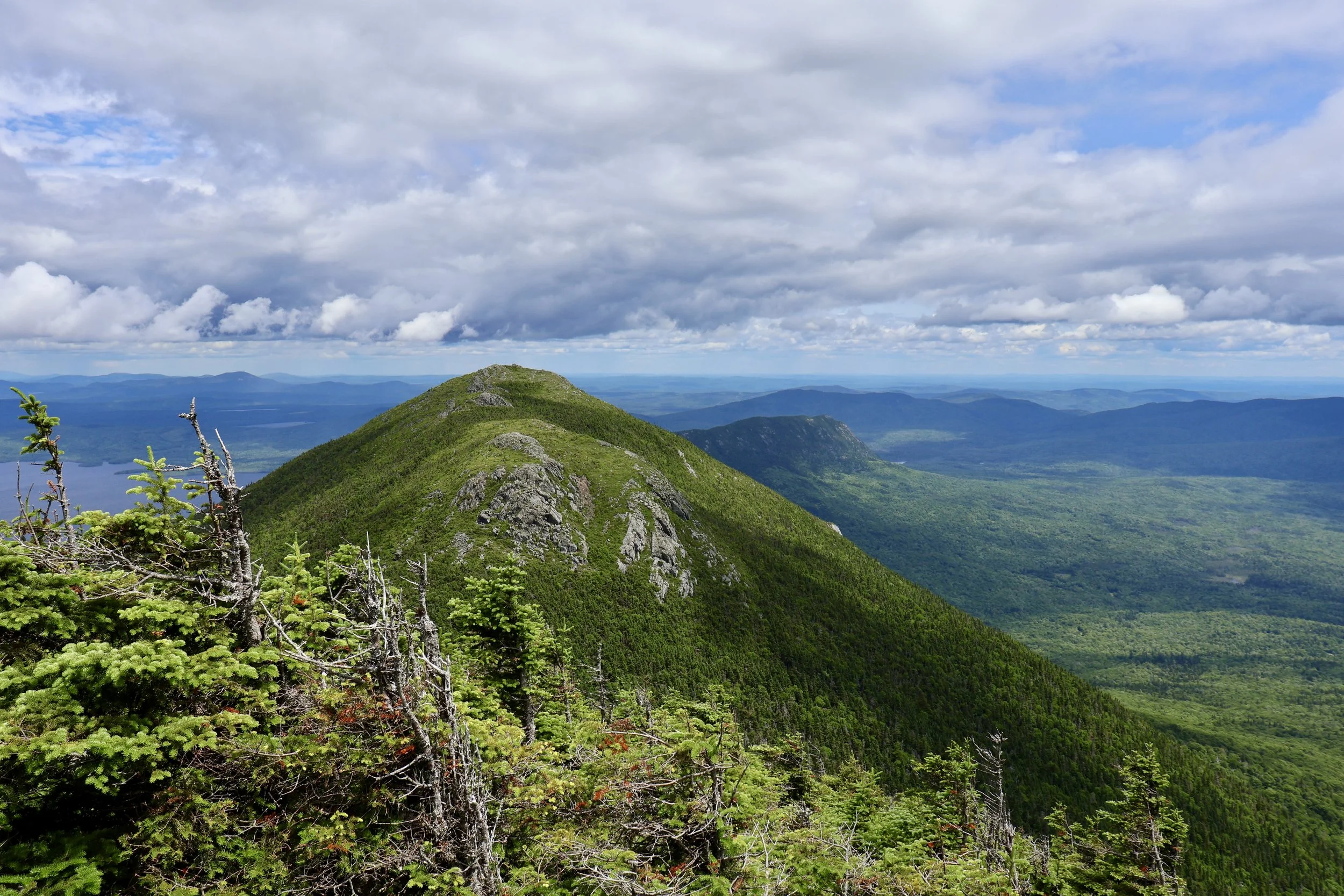
In the morning, we trekked east to the Horns: Bigelow Mountain’s twin North and South Peaks. The trail from camp to the top was our first truly rocky, grueling climb. As a non-native New Englander, I found myself once again sweating and begging fruitlessly for a switchback, any switchback (for real, why aren’t there any switchbacks in this place?). The views, though, made the help-I’m-stuck-in-an-elevator-shaft-like struggle worth it five times over. Flagstaff Lake sparkled to the north and we traced the outlines of some of our favorite Sugarloaf runs to the south.
From there, it was a mostly pleasant, moose-poop-studded hike along the ridgeline to West Peak and then, if you’d like to bag it, Avery Peak as well. We dropped our packs at the Bigelow Col Campsite between the peaks and climbed up Avery blissfully free from the weight of crushed peanuts and damp sleeping bags. The jewel-green vistas were simply astonishing and, best of all, we had all of the summits to ourselves. The destroyed fire tower at the top of Avery was an interesting nod to the range’s history and prominence.


Clockwise starting at upper left: 1) View of Mt. Bigelow; 2) On South Peak with Sugarloaf in the background; 3) Pointing at the Horns; 4) Avery Peak view
⚡ The Storm before the calm ⚡
With towering clouds once again gathering above our heads, we soon hightailed it off the peaks and back down below the treeline. The top of the descent from elevation back towards the trailhead was something I have rarely experienced, both in steepness and in sheer lengthy persistence. If your knees give you any trouble, I would recommend hiking counter-clockwise to ensure that you ascend the chute instead of stepping and sliding down it. By the time we made it back to the car, we were nerve-shot, shaky-legged, and happier than words can describe. It was time to finally point our grimy selves towards fried chicken and home.

A storm brews over Jake on the summit of Mount Bigelow
🥾 Essentials for the trek 🥾
As with any hike in the mountains, it’s best to come over-prepared for adventures like this one. Temperatures can change very quickly at elevation; for this July weekend, I had packed a raincoat, a down jacket, a beanie, and gloves, and wore them all at points throughout the evening and morning. I also always recommend hiking poles, a spare lighter, and a good water filter. As always, it is important to know your limits and to prepare to be flexible should the unexpected happen. Had we been unwilling to pivot and instead stayed with our planned travel direction, we would have been cold, soaked through, and at serious risk of lightning injuries or exposure the first night.
😮 250 Years Later… 😮
All in all, hiking in the Bigelow Range was a stunning, rugged adventure that landed perfectly within the confines of a weekend. I plan to return soon to finish out the rest of the peaks in the series and continue gaping at the endless Maine views. In fact, I now understand why in October 1775, a Revolutionary War patriot named Timothy Bigelow decided to climb Mount Bigelow (without the help of Gore-Tex, packaged food, an altimeter, or likely even a map) “for the purpose of observation.” The staunch Bigelow is now the namesake of both the mountain and the preserve, and I thought of him often as I climbed. In the end, I suppose that I, too, was out there for little more purpose than observation. Observation, and apparently to reopen those blisters just one more time.
Timothy Bigelow’s climb, performed much less eloquently by me and Jake 250 years later
Looking for another adventure? You’re welcome. 😉
Check out our shop - this is how we fund Maine Hikes!
pretty please
pretty please with a cherry on top 😁